You're outside. A plane flies over. Maybe it's lower than usual, or louder, or an unusual shape. You want to know what it is. This is one of the most common aviation curiosities - and it's easier to answer than you might think. Here are five ways to identify aircraft flying overhead, from low-tech to high-tech.

Visual Identification

The oldest method, and still useful. Even from the ground, aircraft have distinguishing visual features:
Size
Regional jets and turboprops are small. Narrowbodies (737, A320) are medium. Widebodies (777, A350, 787) are large. The 747 and A380 are unmistakable.
Engines
Count them and note their position. Under-wing, rear-mounted, two, or four - this alone narrows down the type significantly.
Wings
Swept-back wings are jets. Straight wings usually mean turboprops. Winglets, raked tips, and sharklets are model-specific.
Contrails
Four contrails = four engines. Two contrails = two engines. No contrails at low altitude is normal; persistent contrails at high altitude depend on atmospheric conditions, not aircraft type.
Visual ID works well for low-altitude aircraft (takeoff, landing, pattern work) but becomes unreliable above ~10,000 feet where all jets start to look similar. For cruising-altitude traffic, you'll need one of the technology-based methods below.
Listen to the Sound
Aircraft sounds carry more information than you might expect:
- - High-pitched whine - jet engines, likely a commercial aircraft or business jet
- - Buzzing drone - turboprop (propeller driven by a jet engine), like a Dash 8 or ATR
- - Low rumble from high altitude - large widebody jet at cruise
- - Loud, crackling roar - military jet, possibly with afterburners
- - Thwapping rhythm - helicopter
Sound is most useful for the initial "what category of aircraft is this" question. It won't tell you the exact model or flight number, but it will tell you whether to expect a 737 or a C-17.
Flight Tracking Websites
The most common answer to "what plane is that?" is to open a flight tracking website and match the map to what you see in the sky. The major ones:
FlightRadar24
The most popular flight tracker. Shows aircraft positions on a map with flight details when you tap on one. Free tier has limitations; full access requires a subscription.
FlightAware
Strong on flight status and historical data. Particularly good for tracking specific flights by number.
ADS-B Exchange
Unfiltered, community-driven. Shows military and government aircraft that commercial trackers often block. The go-to for enthusiasts who want to see everything.
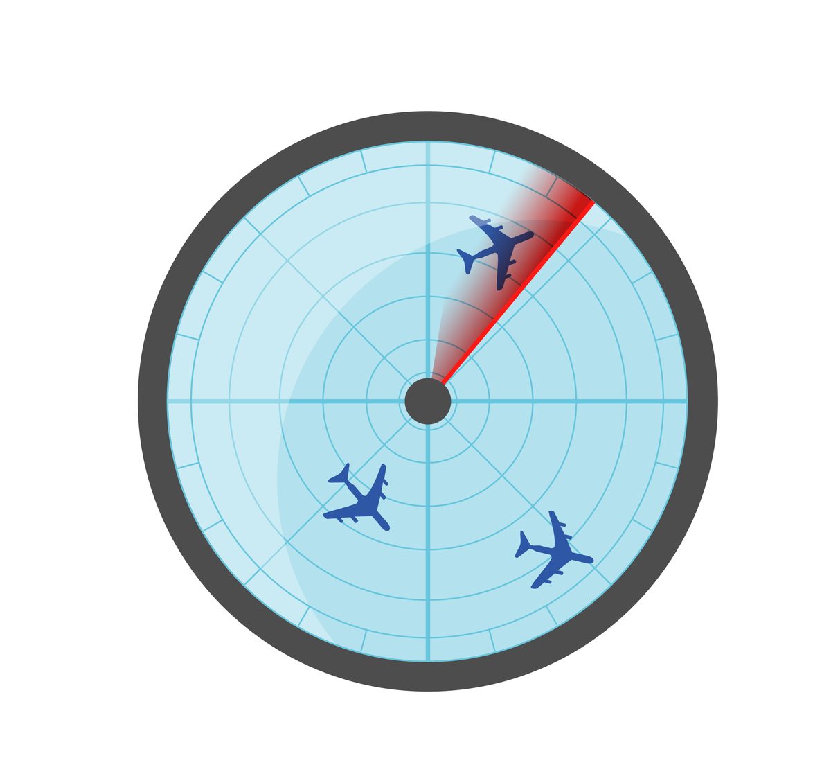
The limitation of all map-based trackers is the same: you have to look at your phone, find the aircraft on a 2D map, then look back up at the sky and try to match them. When there are multiple aircraft in view, this gets confusing fast. Which dot on the map corresponds to which plane in the sky?
Run Your Own ADS-B Receiver
For the more technically inclined, you can receive ADS-B signals directly with your own hardware. The basic setup:
- RTL-SDR dongle - a USB software-defined radio receiver (~$25-35)
- 1090 MHz antenna - a simple whip or purpose-built ADS-B antenna (~$15-50)
- Raspberry Pi or old laptop - to run the receiver software
- Software - dump1090, readsb, or tar1090 for decoding and display
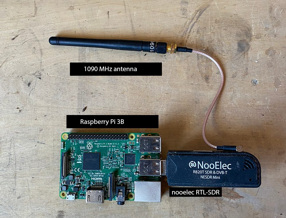
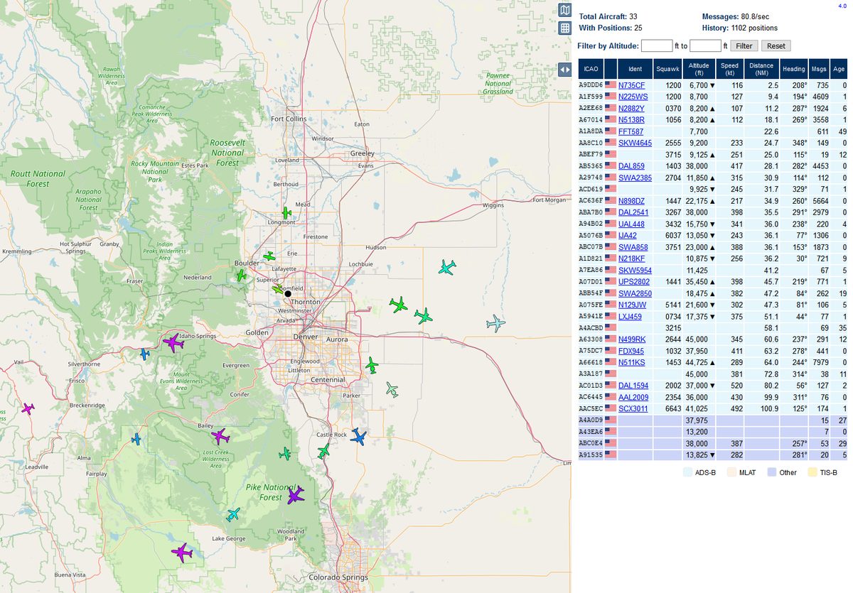
With this setup, you receive ADS-B messages directly from aircraft transponders - no internet required. You'll see every ADS-B-equipped aircraft within line-of-sight, typically 150-300 nautical miles depending on your antenna height. The decoded data shows on a local web interface with a map, aircraft list, and full telemetry.
Many people who run receivers also feed their data to community networks, contributing to the global coverage that powers all of the tracking services and apps mentioned here. It's a rewarding part of the hobby - you're contributing to the aviation data ecosystem.

Use an AR Aircraft Tracking App
This is the newest approach, and it solves the core frustration of map-based trackers: the disconnect between what's on your screen and what's in the sky.
An AR (augmented reality) tracking app uses your phone's camera, GPS, and compass to overlay aircraft information directly on the live camera feed. You point your phone at a plane, and you see its identity, airline, route, altitude, speed, and aircraft type - right there on the screen, aligned with the actual aircraft.

How SkySpottr Works
The result: you look up, point your phone, and get an instant answer. No switching between a map and the sky. No guessing which dot is which plane. The data is right there, aligned with the aircraft you're looking at.
Common Aircraft You'll See Overhead
Depending on where you live, these are the aircraft types you'll most frequently encounter:


| Type | ICAO Code | Category | How to Recognize |
|---|---|---|---|
| Boeing 737 | B737/B738/B39M | Narrowbody | Most common commercial jet. 2 under-wing engines, flatter engine nacelle bottoms than A320 |
| Airbus A320 | A320/A20N/A321 | Narrowbody | Slightly wider fuselage than 737. Sharklet wingtips on newer variants (neo) |
| Boeing 777 | B77W/B772 | Widebody | Large twin-engine. Massive engine nacelles (largest of any twin), raked wingtips |
| Boeing 787 | B788/B789 | Widebody | Raked wingtips that flex upward. Chevron (saw-tooth) engine nacelles |
| Embraer E175 | E75L | Regional jet | Small twin jet. Common on US regional routes. Under-wing engines |
| CRJ-200/700/900 | CRJ2/CRJ7/CRJ9 | Regional jet | Small, with engines mounted on the rear fuselage. T-tail |
| Cessna 172 | C172 | General aviation | Small single-engine prop. High-wing. The most produced aircraft in history |
Identify Every Plane Instantly
Stop guessing. SkySpottr uses real-time ADS-B data and augmented reality to show you exactly what's flying overhead. Point your phone at any aircraft and see its type, flight number, route, altitude, and speed - overlaid directly on your camera. Machine learning confirms your visual lock.